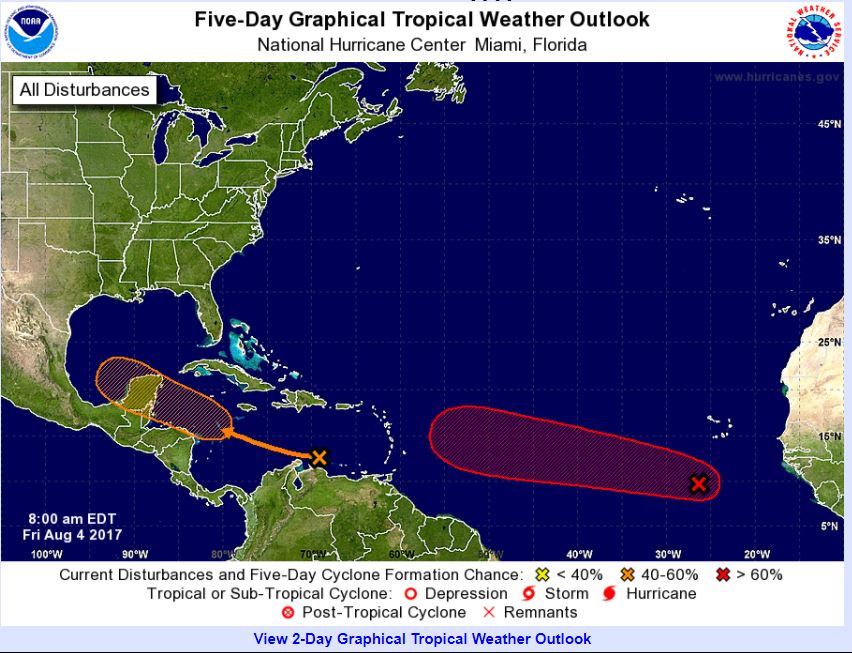
The National Hurricane Center designated 99L yesterday and is predicting an 80% chance that the disturbance will reach cyclone status in the next five days. In addition, we have another disturbance in the central and eastern Caribbean sea with a 60% chance of development.
According to the Atlantic hurricane season forecast update released this morning from the atmospheric sciences team at CSU, an above average hurricane season is ahead. The Tropical Meteorology Project is predicting a total of 11 additional named storms to form after August 1st with eight expected to become hurricanes and three to be category 3 or higher. You can read the entire update here- http://source.colostate.edu/forecast-team-continues-predict-average-2017-atlantic-hurricane-season/
Factors contributing to the busy season include the neutral El Niño-Southern Oscillation (ENSO) conditions and a warmer than normal tropical Atlantic.
While the forecast team notes that these are best estimates of anticipated hurricane activity, they encourage vigilance on the part coastal residents. Quoting Michael Bell, associate professor in the Department of Atmospheric Science at CSU and co-author of the report “It takes only one landfall event near you to make this an active season,”
As we head into the peak period for hurricane development in the coming weeks, it’s only a matter of time before the tropical waves start rolling regularly and storms begin form. We are ready!
Probability of major hurricanes making landfall on U.S. soil:
• 62 percent for the entire U.S. coastline (full-season average for the last century is 52 percent)
• 38 percent for the U.S. East Coast including the Florida peninsula (full-season average for the last century is 31 percent)
• 38 percent for the Gulf Coast from the Florida panhandle westward to Brownsville (full-season average for the last century is 30 percent)
51 percent for the Caribbean (full-season)


